not again lah... aiyoh...
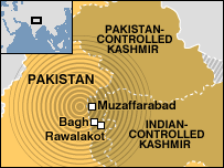
Where are the satellite images… aerial photos… extent of damage maps?? Pakistan and India are scrambling to find satellite images of the disaster area. 20,000 deaths is such a tragic blow to the land of beautiful and breathtaking mountainside. Nature when reveals her fury has no mercy or compassion… what’s damn tragic is many of the victims are children and babies.
Both governments are ill-prepared in analyzing the damage, executing emergency responses and also distributing aid to these people. Times like this we the GIS community or the United Nations should send mapping, imagery and GIS specialists to assist in proper planning, aid and recovery.
Its really sad to know that there is no automated warning system for this earthquake, infrastructure to withstand damage or enough health facilities to handle this huge disaster.
Instead of pointing fingers or blaming others… lets contribute at least something to these people.
If you meet a Pakistani or Kashmiri or the Red Cross… be generous. Lets also pray for them.
Check out more here:
http://tsunami.geo.ed.ac.uk/local-bin/quakes/mapscript/show_map.pl
posted by geotone @ 10/11/2005
0 Comments
![]()


0 Comments:
Post a Comment
Subscribe to Post Comments [Atom]
<< Home