Land Records...
The land we step on… the home we live in… the office we work… the floor we step on… how do you define, present or describe it?? The land , buildings, roads, bridges… and earth… above and below… the sea.. yes, we see with our eyes… and define with our mind… can we really record and define them?? The shape, texture, contour and nature of this beautiful country ... the Peninsular Malaysia and Borneo??
We are surely trying our best… :D
We use a form of art to record all this… we skillfully draft and draw plans or maps to present this land information. But can it really record and define them?? Think about it... You still need to learn and go through many years of training to skillfully read these maps, plans and drawings… Architects, Planners, Surveyors, Engineers, Geographers, Geologists, Draftsman… they all are trained to read, interpret, draw, define and understand maps… and plans… in their own way… in their own profession…
Its an amazing art form for me… all those neat lines, points and curves… the skill of labeling and annotation… colouring and symbolizing … defining what our eyes, body and brains can define… an art that’s perfected throughout history… to present our Mother Earth's Land Records…

Title: Spring in Kurama Temple
Artist: Takeji Asano 1900-1999
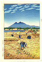
Title: Harvest
Artist: Shiro Kasamatsu 1898-1992
posted by geotone @ 7/02/2005
0 Comments
![]()


0 Comments:
Post a Comment
Subscribe to Post Comments [Atom]
<< Home